HOME > ژتگ^ > ڈو‚蕨پEŒً’ت > Œً’تƒCƒپپ[ƒW > ’nگ}
10,000Œڈ‚جژتگ^‘fچق‚ھŒںچُ‚³‚ê‚ـ‚µ‚½پB
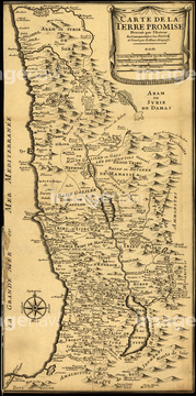
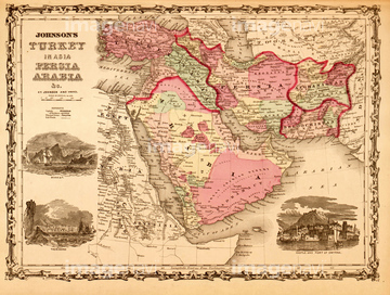
‚±‚جŒںچُŒ‹‰ت‚ة‚حپAMiddle East - Turkey, Persia & Arabia 1862پACanaan, The Land of Promise - 1700پAEgypt, with part of Arabia and Palestine.پAHokkaido, Japan 1854پADAVID KNEELINGپAEastern hemisphere, 1786‚ب‚ا‚ھٹـ‚ـ‚ê‚ؤ‚¢‚ـ‚·پB
51422777
51422779
51423077

51423095
51423139

51422778

51422843
51435955
51435950


51435838

52311858
51435523
51435946


51436132
51435954
51435952
51461477
51436136
51435947

51436130
51435948
51435949

51422780
51435951
51436142

51422774


51422842
51902491


51436140
51436128
51902299
51903563
51435953

51436129
51435525
51902298

64055074

51422840
51435876

51422839

51414341

51414342

51414345

51414346

51414352

51414362
51948530
51901570
51902310

51405927

51405928

51405929


51405937


51405939

51405941

51405944

51405945

51405946

51410014

51410015

51410019

51410020
51435907
51435909
51436320
51436322

51436349
51436355
51435830

64055079
51422776
51902381

51411456

51411444

51411445

51411446

51411447

51411448

51411449


51411451

51411452

51411453

51411454

51411455

51411457


51411459

51411460

51411461

51411462

51411463

51411464

51411465

51411466

51411467

51411468

51411469

51411470

51411502

51411503

51411504

51411505

51411506

51411508

51411509


51411511

51411512

51411513


51411516

51411517

51411518

51411519

51411520

51411521

51411522

51411523

51411524
51436906
51909886
51901739
51435522
51435528

51435514
51435515

64055081

64052692

64055075

51422841
51436141
51435768
51901569
51903428
51417277

51414338

51414339

51414340

51414343

51414344

51414347

51414348

51414349

51414350

51414351

51414353

51414354

51414355

51414356

51414357

51414358

51414359

51414360

51414361

51414421

51414422

51414423

51414424

51414425

51414426

51414427

51414428

51414429

51414430

51414431

51414432

51414433

51414434

51414435

51414436

51414437
| ژںƒyپ[ƒW |
