HOME > ژتگ^ > ڈو‚蕨پEŒً’ت > Œً’تƒCƒپپ[ƒW > ’nگ}
10,000Œڈ‚جژتگ^‘fچق‚ھŒںچُ‚³‚ê‚ـ‚µ‚½پB
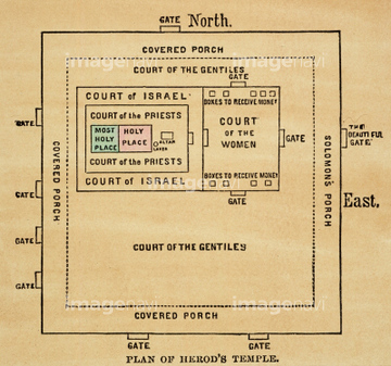
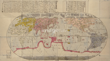
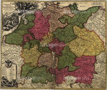
‚±‚جŒںچُŒ‹‰ت‚ة‚حپAJapan 1888پAMap of Asia 1680پAMap of Asia 1791پAMap of Empire Palace in Rehol. 1750پAUniversal map of the Qing Empire. 1767پASolomon's Temple, artwork‚ب‚ا‚ھٹـ‚ـ‚ê‚ؤ‚¢‚ـ‚·پB
51436141

51436137

64055077

64055078
51436139
51436144

51436143

51422780
51436142
51422779
64082664
51417096
64082654
51436135

64082739

51436129

51436130
51916520
51902260

29204774

51435514
51435515
51915641
64082656
51902854
51902300
51436140
51903422
51435517
51435529
51436402

51422778
51435904
51435876
51436313
51435521
51436128
51431363
51436076
51916519
51436316
51435522
51435528

51435535
51435536
51435538
64062253
51493137
51436136
64082661
51436365

64055079
51436239


51436132

51422774


51435838

64055081

64052692


10307301

10307351

10307357
51435861
51436291
51436403
51436405


51405927

51405928

51405929


51405937


51405939

51405941

51405944

51405945

51405946

51410014

51410015

51410019

51410020

51436182
51436208
51436211
51436213
51436215

51436216
51436218
51436219
51436221
51436222

51436223

51436244
51436250
51436252
51436304
51436305
51436307
51436309
51436310
51436311

51436315

51436319
51436323
51436324

51436351
51436352
51436353
51435542
51435555
51435844
51435518
51435520

51411456
51435516
51435523
51435525

51411444

51411445

51411446

51411447

51411448

51411449


51411451

51411452

51411453

51411454

51411455

51411457


51411459

51411460

51411461

51411462

51411463

51411464

51411465

51411466

51411467

51411468

51411469

51411470

51411502

51411503

51411504

51411505

51411506

51411508

51411509


51411511

51411512

51411513


51411516

51411517

51411518

51411519

51411520

51411521

51411522

51411523

51411524

51436318

51435908
51436354
51435563

64055076

64055082

64055073

64052698
| ژںƒyپ[ƒW |
