HOME > 写真 > 自然・風景 > 宇宙 > 地球
10,000件の写真素材が検索されました。
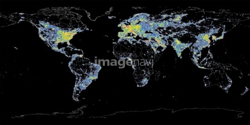
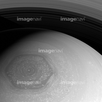
この検索結果には、Global maximum air temperature, 2099、Global maximum air temperature, 2014、Klyuchevskaya Volcano, satellite image、Shiveluch Volcano, satellite image、Saturn's hexagon, Cassini image、Global biosphere, June 2002などが含まれています。

64085878

64085877


64043083


64194875

64043123

64086428

64087817

64053684

64040012

64040015

64072485

64072486

64072491

64073666

64011214

64011231


64053686

64072484

64072487


64072492


64072494

64085876

64085879

64085880

64096326


64066734


64242042

64047887


64072490

64072495

64072496

64075588

64075590

64075591

64109527

64109558


64075684
64086670

64085875
64106254

64040011

64040016

64040980

64075191
64085887

64041895

64073664


64259482

64074360

64074418

64074420


64074421


64074422

64062373

64041230

64074359


64075196

64075197


64088728

64079777

64214597


64052336


64072059

64072060

64073662

64074792
64086442
64078185
64078186

64066108

64066109

64066110

64066111

64066113

64067274

64067275

64067276

64067277

64067279
64075792


64040007

64040010

64040013

64040014

64011215

64011221

64011223

64011225
64045800

64053256

64053257

64053258

64053259

64053260

64053368

64053369

64053371

64053372

64053385

64053561


64074424

64074794

64086667

64074902

64075683


64073665

64061242

64259490

64053315
64075891


64047389


64074871


64044480
64044481
64096325
64045775

64045782

64047888


64067343

64067344
64075592
64075834
64075835
64075836

64075837

64075839

64075841
64075844
64083781
64076172

64067342


64218473
64076173

64040009

64074793

64082370

64041384
64084395

64067330

64011229

64086443

64086444

64089706
64111791
| 次ページ |
