HOME > 写真 > 自然・風景 > 宇宙 > 地球
10,000件の写真素材が検索されました。
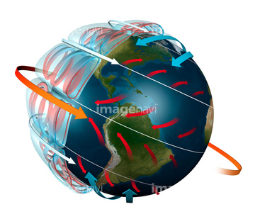
この検索結果には、Pacific phytoplankton levels, 1997-2007、Global chlorophyll levels, 1998-2010、Jet streams, artwork、Indian Ocean, surface temperatures、Antarctic ocean current, computer model、Earth from space, artworkなどが含まれています。
64096326
64096325
64067281

64085877

64085878


64043083
64067284


64043123


64067282

64067275


64085876

64085879

64085880
64067283


64075591
64194875

64087817


64040012

64040015

64040203

64040204

64066108

64066109

64066110

64066111


64066113


64067274

64067276

64067277


64067279


64067295


64067805
64075464

64085887

64062174

64062175
64067288

64048956
64048957


64067291


64047887

64052336

64040011

64040016

64040205

64040206


64011214

64011231

64040014

64011215

64097527

64086428
64086442

64086443

64086444

64086667

64111791

64111792

64078166
64078167
64078185
64078186


64242042


64044426

64044427
64049160


64053686

64040166

64040177

64040178

64040182

64040183

64040980

64041345

64041895
64014701
64014747
64067297

64072484

64072485

64072486

64072487


64072490

64072491

64072492


64072494

64072495

64072496

64073664

64073666

64074902

64075588

64075590

64075683
64075792

64085875

64083582

64022873
64010398
64083581

64086393
64081459


64047888

64066734

64067292

64067293


64088728

64089706

64079777
64204748

64214597


64064274


64053684

64014702


64072059

64072060

64073662

64074792

64075191


64043655
64043656
64043657
64043658
64043659
64043660
64043661
64048952
64048953
64048954
64048955
64048958
64048959
64048960
64048961
64049174
64049175
64049176
64049177
64049178
64049179
64049180
64049181
64049182
64049183
64049184
64049185
| 次ページ |
