HOME > 写真 > 自然・風景 > 宇宙 > 地球
10,000件の写真素材が検索されました。
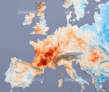
この検索結果には、Gulf Stream ocean temperature、Ocean temperature、Shiveluch Volcano, Russia, from space、Ubinas volcano, Peru, satellite images、Mount Tambora, Indonesia, satellite image、Deep ocean temperature changesなどが含まれています。


64062428


64062426

64062174

64062175

64062425

64088728

64043083

64242042

64040980

64062429


64047887

64075588

64075590

64062373

64061234

64061235

64040166

64011221

64011223

64011225

64011229

64053684


64067331


64109227

64046145

64044794

64044795

64044796

64109527

64109558

64047888


64041230


64109508


64040203

64040204

64040205

64040206


64109563


64087823

64061241

64061242


64014702

64073665

64041390

64064274

64109441

64109442

64109463

64109464


64059356


64092867

64092868


64067330

64087817

64214597

64059353


64059355


64053686

64040011

64040012

64040015

64040016

64041386

64041387

64041388

64041895

64073662

64073664

64073666

64074792

64011214

64011231


64044426

64044427


64067805

64218473

64041383

64086685

64010005


64098684


64058420

64058421

64045644

64040185

64040186

64051876


64049125

64040182

64040183

64135588

64052336

64066734

64092866

64074359


64053700

64057054


64109443

64109465

64152465

64010000


64098666

64098673


64059343

64040007

64040010

64040013

64040014


64074794

64011215


64109433

64109438

64109444

64109460

64045640

64045641
64045642

64045643

64045655


64087812


64096983

64102918

64259482


64259490

64259656


64260474
64211648


64243149

64251605

64046357
64046358
| 次ページ |
