HOME > 写真 > 産業・環境問題 > エネルギー・エコロジー > 環境破壊・汚染
10,000件の写真素材が検索されました。
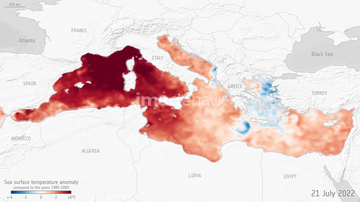
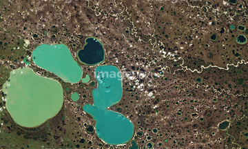
この検索結果には、Marine heatwave, July 2022、Ponds forming from thawing permafrost, satellite i…、Heatwave, conceptual image、Global warming warning, conceptual image、Drought、Global warming, conceptual imageなどが含まれています。
17200266

64015263


64014936
64014937
64015298
64045846
64053576

64040203

64040204
64242515

64092867

64092868
64058146
64011298
64011299

64043800
64043801
64043802
64042397
64201808

64015133
64256538
20555808
64014929
64014939
64014958
64206692
64206693

64092866
64014757


64040980
64097620

64014758

64058420

64058421
64058141

64041390
64116359
64116360
64015277
64254089


64040205

64040206

64040166

64109527

64109558

64041230
64113689

20506144
64037651
64015234

64109441

64109442

64109463

64109464

17274214
64155953
64043474
64047394
64067518
64067523
64067524
64071961
64097254
64014715
64015139
64011304

64043083

64242042

64179521

64073664
64040993
64113443

64109563
64254063
64220049

64047887


64014421

64125742
64165188
64165189
64014926
64113160

64045644

64088728
64108822

64059343
64067360
64067361


64014773


64059355


64073665

64092865

64144994
64046247
64015208
64015136
64015236
64015238
64015239
64015242
64015243
64015244
64015245
64015246

64061241
64011303
64011306

64201790
64190777
64015284
64015286


64062428


64047888
64088702
64041288
17200295
64203129
64203130
70081796
| 次ページ |
