HOME > 写真 > 自然・風景 > 宇宙 > 地球
10,000件の写真素材が検索されました。
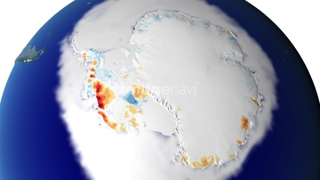
この検索結果には、West Antarctic Ice Sheet melting、Bering Sea, satellite image、Wilkins ice shelf, Antarctica、Hurricane Harvey over Texas, USA, satellite image、Global biosphere, October 1997、Aral sea, 2013などが含まれています。


64149337

64109509


64149307

64208339


64149139


64131456


64109506

64014771


64079777


64061242

64062425

64062429

64046145

64075588

64075590

64219636

64106283

64049194

64108861

64109508


64044574


64057054

64064274

64067282
64093901

64057060
64088702


64170235

64170236

64084875

64076181


64243149


64062426


64062428


64064290


64067332

64067333


64109560

64200497

64217603

64077812

64203337


64220039

64057050

64057051

64057052


64057061


64057064


64067334

64067335

64067336

64067337

64109441

64109442

64109463

64109464


64105772

64059717

64089327


64111650

64164839


64243450

64062430


64088450


64116186

64116187

64116188
20543664

64109433

64109438

64109443

64109444

64109460

64109465

64109439

64109440

64109461

64109462

64109473

64109475

64109527

64109558

64109563

64218100


64078685
64091491


64014773

64197367

64140770
64040993
64109677


64264125


64152470

64067286


64057614

64185232

64185233

64185234

64185235
64185237

64185238

64185239

64185240

64185241

64185236


64109466

64109469

64109476

64188515

64188516
64188518

20543741

17200256

17200257

17200258
| 次ページ |
